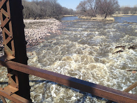
The new rock dams drop roughly 13 feet within 225 feet. When we Dan and I first got there we scouted out the place to see the best spot to get in and end. Our first view under the closed bridge at the end of the rapids got us a little frightened we didn’t expect that big of waves and holes. We decided it would be best to take the far west said on the South Dakota side. At the beginning of the rapids there is a small island I started on the west side of the island going over some tree branches that have floated down and got caught in the first set of rocks. As the video attached you can see I kept mainly to the west side and it took about 30 seconds to make it through the rapids. There were some fun waves about 2 feet tall. I hit a few rocks on the way down but more at the beginning at the first couple of rock arches.
The second time down Dan decided to come with me and we also made the decision we were going to try to middle of the rapids because the waves seemed a little bit bigger. We started on the west side about 200 feet from the bridge on the South Dakota Side. We actually paddle up river to go around the little island and go down the river on the east side (Iowa side). This actually worked out perfect because it placed us dead center of the rapids. We did have to avoid some lodged trees for safety of any strainers. We did not video this one since we were both kayaking it. I would say it took about 30-35 seconds to do this stretch. The waves I would say were 4 feet at the end which were amazing. The water was cold on our face but luckily we were dressed with dry top, john wetsuit, scuba boots, paddle gloves and skirt so only our faces got cold. It was a good roller coast ride and didn’t hit any rocks. When we got done a prospector actually said he took video and is willing to send it to us so hopefully will be getting that soon. I would recommend this to anyone that has a beginner to intermediate skill in whitewater kayaking and bracing. A skirt, helmet, and throw bag is a must (for best safety). I would not attempt this with a recreational kayak do to water over flowing kayak. We found out that the water at this time was 925 CFS at 4:30PM 4-3-13. The weather was great the sun was shining and it was about 60 degrees. It was windy that day but down by the old Klondike Dam it was not windy at all. I will keep an eye on the CFS flow rate and if it gets above 925 again I will hopefully have another story with pictures and video.
Video of me going down Klondike Mill Dam!!
Here are some online links for more interesting information on the Klondike Mill Dam in the Big Sioux River.
New Century Press >> Dam demolition http://www.ncppub.com/pages/?p=5240
BIG SOUX RIVER – US Department of the interior http://www.doi.gov/news/pressreleases/upload/Iowa-Big-Sioux-River-Final.pdf
Klondike Mill Dam – Iowa Whitewater Coalition http://www.iowawhitewater.org/lhd/LHDklondike.html
Northwest Iowa dam replaced with rocks http://www.careersatquincy.com/story/21812235/2013/03/27/northwest-iowa-dam-replaced-with-rocks-klondike-dam
The 2010 River Dam Inventory – Iowa Department of Natural Resources http://www.iowadnr.gov/portals/idnr/uploads/riverprograms/dam_chap2.pdf
Northwest Iowa dam replaced with rocks – KTIV News 4 Sioux City http://www.ktiv.com/story/21812235/2013/03/27/northwest-iowa-dam-replaced-with-rocks-klondike-dam
IOWA DEPARTMENT OF NATURAL RESOUCRES http://www.iowadnr.gov/Portals/idnr/uploads/Natural%20Resource%20Commission/2012-11-08%20NRC%20ai.pdf


No comments:
Post a Comment